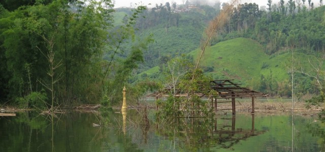
Photo: The exposed tip of the Ywar Gyi Village pagoda and the top floor of the village monastery, part of new village visible high on hillside (Photo/Alec Scott)
Alec Scott (Burma Campaign, UK)
The Upper Paunglaung hydropower dam is scheduled to begin generating electricity for Burma’s capital, Nay Pyi Taw, in January after the dam’s floodgates were closed in July last year. Since early 2013 over 8,000 people have been displaced from their homes, farms, schools, and religious sites in south western Shan State’s Paunglaung Valley, located just 50 km east of the capital, where a 60 sq km reservoir now dominates the landscape. Displaced farming communities have constructed new villages on the steep, muddy hillsides surrounding the rising reservoir where a lack of clean water and a poorly planned resettlement process has been exacerbated by inadequate compensation and a complete lack of replacement farmland resulting in many families’ now struggling to subsist.
As part of a joint venture with the Union of Myanmar’s Ministry of Electric Power (MOEP), the design and construction of the dam has been overseen by the Swiss engineering consultant Colenco AG, acquired in 2007 by the AF Group, the Sweden based international energy giant. British and German firms Malcolm Dunstan & Associates and FOSCE Consulting Engineers – both self-proclaimed experts in Roller-Compact Concrete dam building – have acted as design and construction consultants. Machinery and capital has been provided by China’s Yunnan Machinery Export Company. This capital intensive hydropower project has dispossessed more than 1,500 low income rural households, from 24 villages, of their livelihoods in this highly fertile valley.
Double Displacement
In October 2014, the profound absence of transparency and information sharing between project developers and local communities became apparent when at least four resettlement sites were flooded resulting in hundreds of families being forced to dismantle their newly built homes and abandon their crops and vegetable gardens as the reservoir waters continued to rise above levels predicted by government officials.
In early October, villagers displaced onto the hillsides in the northern reaches of the dam’s reservoir were visited by officials from the Department of Hydropower Implementation (DHPI) who warned communities; “Be careful living here”. But as U Doe Khine explained as the flood-waters lapped against the bamboo foundations of his house “Before the dam gates closed we were told we could move to this place, that it would not flood, and that the land was safe”. Almost a year ago U Do Khine, his wife Myint Moe and their five children were driven to uproot their home and abandon their farm receiving just 600,000 Kyat (600 USD) in compensation. Their old village, Nan Sa Kin, home to a community of 62 households, was now divided in two by the flood and households were forced to resettle miles apart. In the new village, eight houses have been inundated and residents forced to uproot once more and begin again further up the hillside.
Yay Soe Village, a farming community of 134 households on the north-western edge of the flood zone was not even part of the government’s ‘flood plan’. Surrounded by hills and dense forest this community of roughly 600 people is now accessible only by boat as the one road leading out of the village was inundated in mid-September 2014. By early October the first of the villagers’ rice paddy fields were flooded. Two weeks later, two farmers had already lost substantial amounts of their of rice paddy. U Saw Lai’s eight acres of farmland provided work for as many as 20 people, including his five sons, during the sowing and harvesting of two annual crop cycles. Fifty year old Daw Byout also lost eight acres of rice paddy to the flood that submerged her land before she was able to harvest.
The old road in and out of Yay Soe Village has been submerged cutting farmers off from the market where they trade their crops and buy essential medical supplies. Students have lost contact with the local high school, now out of reach, while pregnant women and the seriously ill are no longer able to reach the hospital in Nay Pyi Taw. Without a boat until late November the community has been marooned by the rising waters, bereft of government support, consultation or compensation from the DHPI or the Land Department.
According to local villagers, it wasn’t until October 12th 2014 that officials from the DHPI began demarcating the high water mark by carving notches into trees. Just over a week later, around October 20th, the Land Department made the rounds, this time using a system of yellow flags to map out land slated to be submerged in the coming weeks. According to one villager who will remain anonymous, “when the land started flooding they came to measure the water levels, and made marks in the trees.” “The water will just come this high so you don’t need to worry”, they said. But finally it comes higher than they think. “When they came and measured it in detail, exactly, it is higher, and the villagers realised that they will lose a lot.” At this point the valley had already been flooding for three months while its former custodians watched their farms, monasteries and ancient pagodas disappear below the murky brown waters.
Lessons from Paunglaung
At the site of another hydropower dam project currently under construction on the Myitnge River – a major tributary of the Irrawaddy River – in northern Shan State, a video recording shows the young, smartly dressed director of the No.4 DHPI, Hein Htet addressing a gathered delegation of Tar Long villagers and Shan politicians: “At Paunglaung 24 villages have moved into a town. It’s all convenient. . . . Things are going to be so much quicker. You will have free time. Things are so much quicker with electricity.”
Tar Long Village in northern Shan State has been marked for inundation beneath the waters of the Upper Yeywa dam project. The communities only choice, according to Daw Oh Mar, a government backed researcher working for the project, is between three government-mapped relocation sites. When the villagers of Tar Long were finally given their chance to speak the village headman, Lung Aw Sing Na, stood and addressed the proponents of the project: “After you have learnt about our community and our land, you will see why we don’t want to relocate, we don’t want any compensation from you, and we won’t move. Even if you give lots of money for compensation, it won’t help us as we only know how to farm in our area. We grow oranges and pomelo. We are famous for producing these fruits.”
The rupture of displacement has had varying impact within and between communities from the Paunglaung Valley, yet the majority of residents have begun to reshape their livelihoods around hillside plots of shifting rain fed crops. “In the valley we depend on the river, on the mountain we depend on rain”, reasoned U Han Tin. The practice of shifting cultivation, also known as Taungyar in Burma, has become widespread on the hillsides above the reservoir and relies on the slashing and burning back of forest so that crops can be sown into the hillsides before the rains. This agricultural method is often used in mountainous areas where rivers cannot be used to irrigate fields and water catchments are insufficient for fixed terrace agriculture. In contrast to river-fed farms, Taungyar must shift to new land each season and is unproductive during the rain-less months of summer delivering less than half the yield of river-fed rice paddy per acre.
With regular work scarce many young men have begun to leave their communities in search of jobs, some have found work in mines such as Mawchi and Long Kheng. “There are many workers but not many jobs. Before there were many farms and there was always jobs. Right now there is no more farms . . . no more work”, stated Daw Aye, a thin but resolute middle aged woman from Kyaun Ywar Village. There is work building the power lines for 3,000 Kyat (3 USD) per day. “Not many people get this work. One in 50 get this work for maybe 15 days a month”, explained U Aung Dau, a member of the local village committee.
In the scattered resettlement sites above the flooded Paunglaung Valley the continued absence of replacement farmland has forced almost every household to reclaim large plots of land from the forested hills above the reservoir in an effort to carve out a new income. In July 2013, U Win Soe, the Pinlaung district administrator, informed the Myanmar Times that alongside compensation for the revenues farmers would have raised from their regular harvests; “[w]e will also create fields for cultivation in the new villages.” The issue of farmland is not the responsibility of the DHPI who have explained to villagers that the allocation of new farmland is now in the hands of the Land Department. Yet, none of the communities we interviewed had met anyone from the Land Department. “They sent us a map of our new farms, but this is only a map and not reality”, explained U Han Tin of Kahnla Village.
To date none of the displaced households from the Paunglaung Valley have received replacement farmland.
Prime Minister Thein Sein and the military dominated government have inherited a long list of planned hydropower projects, conceived during Snr. General Than Shwe’s military dictatorship (1992-2011), and based largely on a model of energy export to south western China and Thailand. Thirty-seven of the 53 large dams are being planned and built in areas of the country where state power is widely associated with military occupation and human rights abuses, as protracted armed conflicts between the Burma Army – AKA the Tatmadaw – and Ethnic Armed Groups continue to flare in the absence of political peace settlements. In areas such as Paunglaung, just 50km from the nations glistening capital, while there is no rattling of gun fire or pounding of mortar rounds, one villager who spent his youth evading the Tatmadaw states that, “the pressures are the same as in a warzone.”
Alec Scott is a lead researcher for Burma Campaign UK specializing in forced displacement, militarized development and land use rights in Burma (Myanmar). He has over 6 years of Burma and Thailand-Burma border-areas research experience and an MA in social anthropology from the School of Oriental and African Studies. During the last 2 years he has conducted field work in Burma in both state and non-state areas of Mon, Karen, Karenni, Shan and Kachin states.